Overseas Training > 2009 > Rusnardi Rahmat Putra
Rusnardi Rahmat Putra
Questionnaire survey for estimating seismic intensity distribution during 2009 Padang earthquake
 Division of Earthquake and Lifeline Engineering, Department of Urban Management, Graduate School of Engineering
Place of stay: Padang State University, Indonesia
Term: November 18, 2009 – January 26, 2010
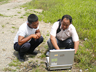
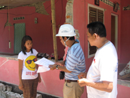
The Indonesian archipelago is located on the boundaries of the four major tectonic plates: Indian, Australian, Filipino and Eurasian plates. Thus Indonesia has experienced many earthquake disasters. Padang city, which is the capital of West Sumatra province of Indonesia, has been struck by several powerful earthquakes, and is well known as one of the regions with the highest seismicity in Indonesia. On September 30, 2009, a 7.6-magnitude earthquake hit Padang and caused more than 1,000 casualties. Following the event, I joined the joint investigation team of JICA and Padang State University. We conducted a questionnaire survey for estimating shaking intensity distribution during the earthquake. About 600 residents in all parts of Padang city were interviewed. The residents received explanations on each item of the questionnaire by the interviewers, and filled answers on answer sheets. From this survey, we collected 600 questionnaires about several events occurred in 2007, 2009, and 2010 and developed a map showing shaking intensity distribution of Padang. Then we compared a proposed relation between PGA (Peak ground acceleration) and MMI (Modified Mercalli intensity scale). In addition to the questionnaire survey, we performed microtremor observations at 70 sites in Padang. The obtained results enable us to estimate the site-dependant characteristics of earthquake ground-motion amplification.